Overall Comments
First a disclaimer about my tour analysis… I use Mapmyride.com for stats and graphs… It’s a great tool people can use it for their own routes or for finding those created by others. Mapmyride software now reports the categories of climbs: 5 being the easiest of climbes (at least 500 meters in length and a 3% grade) up to Cat 1 and HC (very long, very steep and/or very high). That, compared to the grade chart should gove you a good guess for the difficulty of the day. Also… please note, I do not have access to the actual route plan. I am using my guesstimate of the most likely route the tour will use between two cities (and in UT, that's easy as there are not too many alternative routes). As such, my miles and climb numbers may be off a bit. However, on the route for 2014, the only real variables are routings within the cities, use of frontage roads, and an odd turn here or there. My bigges guess is the last day: I get us to Zion, but I don't know how the tour plans to get us through Zion. BUT, just in case, be warned that I may miss a turn or two, although I don't think I have. Also, sorry that I don't have any pictures. I have not ridden through UT before and I always use only my own pictures.
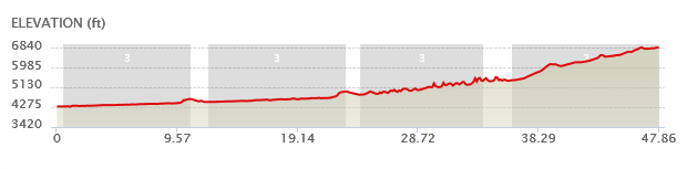
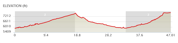
Blanding UT to Halls Crossing UT
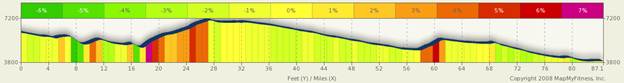
Mile 9.5 for 2.36 miles, 3.1% climb 400 ft, Cat 5
Mile 15.7 for 1.1 miles 2.6% climb 100 ft, Cat 5
Mile 18 for 10.2 miles, 4% climb, 2200 ft, Cat 1
Mile 59.5 3.7 miles. 4.4% climb, 800 ft, Cat 3
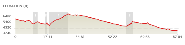
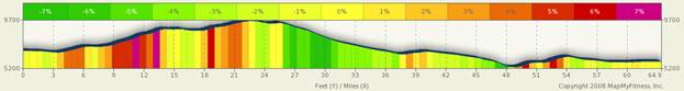
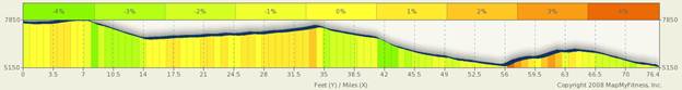
Halls Crossing to Hanksville UT

Mile 5.3 for 4.7 miles, 2.3% climb 500 ft Cat 4
Mile 14.6 for 11.2 miles, 2.7% climb 1400 ft Cat 2
Mile 34.2 for 1.5 miles, 3% climb 200ft Cat 5
Mile37 for 2 miles, 2.8% climb 300 ft Cat 5
Hanksville to Torrey
One climb, all day (with a few short downs, 1.5% climb 2500 ft Cat 3
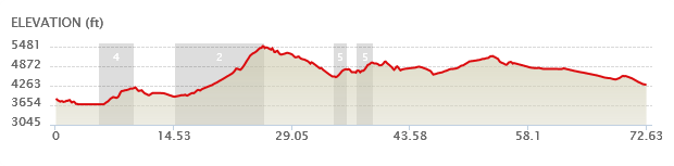
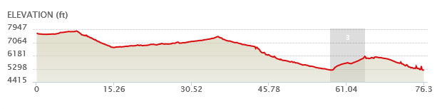
Torrey to Escalante
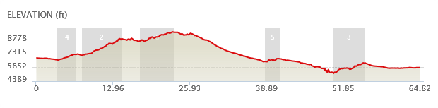
Mile 3.5 for 3.1 miles 3.5% climb 600 ft Cat 4
Mile 7.7 for 6.6 miles 4.8% climb 1700 ft Cat 2
Mile 17.5 for 5.8 miles 3% climb 900 ft Cat 3
Mile 38.5 for 2.5 miles 2.1% climb 300 ft Cat 5
Mile 50.1 for 5.2 miles 3.6% climb 1000 ft Cat 3
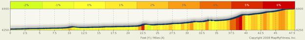
Escalante to Ruby’s Inn
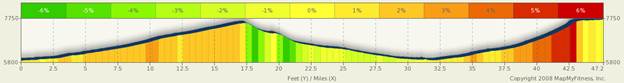
Mile 0.6 for 18 miles 1.8% climb 1700 feet Cat 2
Mile 33.4 for 13.5 miles 2.5% climb 1800 feet Cat 2
Ruby’s Inn to Springdale
Low confidence on the end of this ride. I have no idea if you ride or shuttle through Zion. I assume Shuttle, but then not sure where or if we shuttle all the way to Springdale. These maps assume stopping short of Zion and then shuttle to Springdale.
One climb of significance, Mile 57.8 for 6.8 miles 2.3% 800 ft Cat 3