Afton Hills

Last update: 12/2009
Fact Table:
| Location | Twin Cities-South East |
|---|---|
| High point | 1037 ft |
| Max Grade | 16% |
| Route Distance | 60 mi |
| Elev Gain | 2000 ft |
| Rating | Moderate |
| Access City | Afton, MN |
Ride Tips:
Several sections of rough road. Use Caustion
Not many services on southern leg, bring food and water
Afton has nice cafe's for a break
Watch traffic in Afton
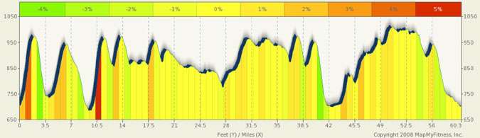
This is a great training ride as it gives you 60 miles of riding and 2000 feet of climbing very close to the Twin Cities. It’s very scenic and rides through both Afton State Park and the St Croix Bluffs park. It’s a great ride any time of the year (I avoid winter riding) as it is scenic and has fairly low traffic. However, I like the ride best during the fall color season.
There are a number of steep climbs on this ride and while they may be short, they will get the blood flowing. Right from the start, the climb up Afton Hills Dr is 11%+. Also in the 11% range is the climb away from the river on 50th st (and it’s also a fairly long climb) and the climb out of Afton State Park. St Croix Trail Rd between Afton and Afton Park has a few rollers in the 6% to 8% range, and just south of the park leading up to St Mary’s Church, you’ll find a 14% climb. Rollers along the rest of the course keep you interested.
Roads are being paved and replaced on the southern leg of this ride. If you run into a gravel road, it will only be short lived and they are fairly smooth.
Mi |
Start |
|
0.05 mi |
Take the 1st left onto St Croix Trail S |
|
0.5 mi |
Slight left at Co Rd 21/Stagecoach Trail S |
|
0.75 mi |
Take the 1st left onto Afton Hills Dr S |
|
1.5 mi |
Continue onto Afton Hills Ln S NOTE: Road and loop at top of climb was kind of rough last time out. Use caution |
|
2.25 mi |
Continue onto Afton Hills Dr S |
|
2.6 mi |
Continue onto Afton Hills Ln S |
|
3.35 mi |
Take the 1st left onto Afton Hills Dr S |
|
4.57 mi |
Turn left at Valley Creek Trail |
|
4.99 mi |
Take the 1st left onto Trading Post Trail S |
|
6.95 mi |
Turn left at Afton Blvd |
|
8.77 mi |
Turn right at St Croix Trail S |
|
9.33 mi |
Turn left at River Rd S NOTE: road was pot holed lat time out. Use caution here, it's only a short segment |
|
10.36 mi |
Continue onto 50th St S |
|
12.03 mi |
Take the 1st left onto St Croix Trail S. Follow 70th into park and take road to end and then return |
|
18.54 mi |
Turn left St Croix Trail S |
|
21.74 mi |
Take the 1st left onto 102nd St S into park, ride to end and return. |
23.86 mi |
Take left onto St Croix Trail S and continue south. |
|
| 28.30 mi | Turn around at Hwy 10 and backtrack on St Croix Trail | |
29.39 mi |
Turn left at 122nd St S |
|
30.65 mi |
Turn right at Neal Ave S |
|
33.89 mi |
Turn right at 90th St S |
|
35.86 mi |
Turn left at Co Rd 21/St Croix Trail S |
|
41.55 mi |
Turn left at River Rd S |
|
43.92 mi |
Take the 1st right onto 15th St S |
|
45.58 mi |
Turn left at Co Rd 21/Stagecoach Trail S |
|
45.88 mi |
Take the 1st right onto 15th St S |
|
48.93 mi |
Turn right at Co Rd 15/Manning Ave S |
|
52.46 mi |
Turn left at 50th St S |
|
54.99 mi |
Turn left at Trading Post Trail S |
|
57.93 mi |
Take the 1st left onto Trading Post Trail S |
|
58.35 mi |
Turn left at Valley Creek Trail |
|
59.82 mi |
Slight left at Co Rd 21/Stagecoach Trail S |
|
60.27 mi |
Take the 1st left onto 34th st S |
|
60.3 mi |
|
Stop |