Gateway Trail-Stillwater Loop

Last update: 11/2020
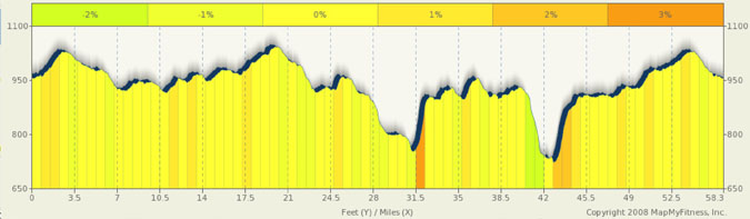
Fact Table:
| Location | Twin Cities East |
|---|---|
| High point | 1070 ft |
| Max Grade | 11% |
| Route Distance | 58 mi |
| Elev Gain | 1100 ft |
| Rating | Moderate |
| Access City | Hwy 36 and 694 |
Ride Tips:
Carry water and food with you. This is fairly rural
Food and water can be gotten in Scandia, Marine on St Croix, and Stillwater.
Water and restrooms found at both ends of trail
Gateway Trail can get crowded with bikers, skaters, walkers, and horses. Be kind.
Here is a nice scenic route that incorporates the Gateway Trail to escape the Twin Cities and get out to Stillwater. A nice warm-up on the 9+ mile segment of the trail drops you just north of Stillwater. By heading further north to and beyond Scandia you’ll find rolling hills, great roads and little traffic. After Scandia, you’ll head south on 95 (fairly low traffic here), past William O’Brian park to Marine on St Croix and then turn west for more climbing and rolling hills. As you twist and turn in the hills, you’ll end up in Stillwater for a quick break, then up Mrytle Hill, back to the trail, and return to your starting point. It’s a great ride and is not too hard to do. It’s great for early season training.
The Gateway Trail follows the south side of Rt 36 from Margaret St to 694. I recommend parking at the Gateway Trail parking lot off of 55th St N. (From 36, turn south on Hadley, then immediately east on 55th and follow 55th almost to the end where you will find the lot). The lot fills up early on weekends, so park where allowed on 55th if full.
0 mi |
Start: From the Gateway Trail Parking lot off 55th. Turn left (east) onto the trail and follow to the end. |
|
9.7 mi |
Turn left at Norell Ave N |
|
11.01 mi |
Turn right at Square Lake Trail N |
|
11.57 mi |
Turn left at Norell Ave N (Co Rd 55) |
|
15.26 mi |
Turn right at 170th St N (Co Rd 4) |
|
15.69 mi |
Turn left at Olinda Trail N (Co Rd 3) |
|
23.22 mi |
Turn right at 240th St N |
|
24.9 mi |
Turn right at MN-95/St Croix Trail N |
|
32.75 mi |
Turn right at Nason Hill Rd N (Co Rd 7) |
|
34.35 mi |
Turn Left at Paul Ave N to stay on Co Rd 7 |
|
36.38 mi |
Turn left at Partridge Rd N (Hwy 51) |
39.37 mi |
Turn left at Stonebridge Trail N (Co Rd 82) (At intersection with St Croix Trail) |
|
41.08 mi |
Turn left at Otchipwe Ave N |
|
42.3 mi |
Continue on Fairy Falls Rd N |
|
42.84 mi |
Slight right at Boone Rd |
|
43.09 mi |
Turn left at Dellwood Rd/MN-96 |
|
43.16 mi |
Turn right at MN-95/St Croix Trail N Continue to follow MN-95 |
|
44.48 mi |
Turn right at E Myrtle St |
|
45.87 mi |
Continue on 75th St N |
|
47.33 mi |
Turn right at Manning Ave N (Co Rd 15) (Note: If you feel like shaving off a few miles, do not turn on Manning, just continue on 75th for about 3 miles and you’ll cross the Gateway Trail. |
|
50.58 mi |
Turn left at Gateway State Trail and follow back to parking lot |