Stillwaters Run Deep

Last update: 12/2009
Fact Table:
| Location | East Central MN and West Central WI |
|---|---|
| High point | 1129 ft |
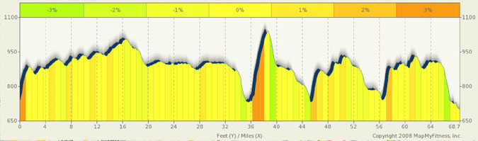
| Max Grade | 14% |
| Route Distance | 69 Miles |
| Elev Gain | 1500 ft |
| Rating | Moderate |
| Access City | Stillwater, MN |
Ride Tips:
Watch for traffic in Stillwater, Taylor Falls and Lindstrom.
Watch downhill speeds as there may be sand on the roads
This route incorporates the great town of Stillwater and it’s Mrytle Hill, Scandia, Taylor Falls, and a small jaunt into Wisconsin. For the most part, it is a low traffic high scenery route. This route uses a number of hilly MN back roads on the outbound leg. The worst traffic will be on Lake Blvd from Lindstrom to Taylor Falls (especially if you do this ride during the fall color season) and in Stillwater. The traffic on 95 is actually quite light approaching Marine on St Croix and then you are back on side streets into Stillwater.
This hill is full of rollers and includes a few great climbs, particularly Mrytle Hill (12%), the climb into WI out of Taylor Falls (7% max), the climb out of Osceola (12% max), the climb approaching the Scandia area (from Osceola) (8% max), and a great climb on County 7 coming off 95 (14% max). I usually hit this route early in the spring and again in the fall color season. Taylor Falls is a great place to stop for a burger and root beer float in addition to the enjoying the scenery. Scandia and Lindstrom are nice towns to stop in for breaks (and the sandwich shop in Scandia at Olinda and Oakhill across from the church still offers small town prices for sandwhiches).
The start of this ride is in Stillwater on the St Croix river. Watch where you park and Stillwater has reduced the parking times in many of its free lots to only two or three hours.
|
|