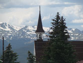
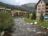
 Copper Mtn
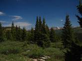 Route from Copper up Fremont Pass
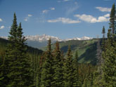 Approaching summit on Copper Mtn side
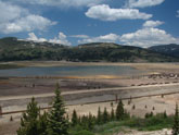 Turquoise Lake
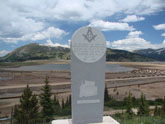 Turquoise Lake historical marker.
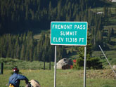 Fremont Pass
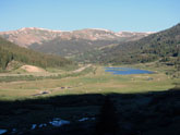 Leadville side of Fremont Pass.
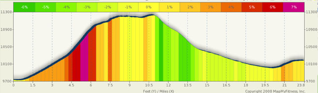
Fremont Pass Summary
This is kind of a strange pass. The north and south faces couldn't be more different. To the north, Summit County and Colorado’s winter and summer playground. To the south, mining and ranchland, giving way to the agricultural banana belt in CO. While it’s not one of my personal favorites, over time, this pass has grown on me. I’ve ridden it more times than I wish to admit, as this is a very convenient and fairly pass to access two very different parts of Colorado. Personally, my biggest issue with this pass the 4-5 mile plateau at the top. I like downhill riding and for me, the only reward for tolerating a climb is the instant gratification of a downhill after you summit. Rabbit Ears and Gore are similar, but they have short downhills between the peaks. Not Fremont. From either direction, you climb to the top, and then climb some more. When you finally hit the top, you’re faced with rollers. This is most noticeable if you are riding from Leadville to Copper Mountain. My other memories of this pass… the wind. I don’t care which direction you are going, in 100% of my rides here, I had to contend with a headwind.
Having said all of that, the north side of the pass gives you some of the most diverse scenery Colorado can throw at you and, for that reason alone, this is a good pass to climb. You start in the heart of Summit County and heavily forested terrain and climb to high plateaus and mining country.
From the North, starting at Copper Mountain, you almost immediately start a constant climb. The first five range from 2% to 3% grades. Ten-mile creek is tumbling downhill to your left as you climb. If you take one of the several turnout areas on the left, you will find the creek cascading over numerous waterfalls. However, at mile 5, the grade ramps to first 6% and then to 7 and 7.5%. The grade does not back off until after mile 6.5. The final assault, about a mile from the top, brings you in at steady 5%, but a short section hits 7.5%. From this point, you are squarely in mining country. Vast trailing ponds to the right, and endless peaks to the left. And, just shy of the summit itself, you find strip mining at its finest. While the mine is currently closed, there are efforts underway to revive it (whether that’s good or bad, it’s up to you). Also, there has been a lot of press lately on impending doom as there is apparently a lot of water dammed underground threatening to wash over Leadville. Hasn’t happened yet… we’ll see if it ever does.
From Leadville, the climb is a little less daunting but every bit as long. The run-up to the real climb will take almost 8 miles of the climb and during much of this segment, the climb is only 2% or 3% (and you have a mile or two descent from Leadville to start the ride). The real climbing starts about three and a half miles below the summit. Actually, as you ride from Leadville toward the pass, you’ll spend a fair amount of time looking at the final ramp as it completes its arching left hand turn upwards. It looks a lot worse than it really is and it is fun to look over to your left as you leave the valley floor below you. The rest of the climb is fairly short and only briefly steep.
In either direction, there really are no sharp turns or switchbacks and the run-outs for the downhills are nice and straight. Both directions have good shoulders and, depending on wind, could allow for some nice speed. The south side downhill is short and after the initial drop you will need to pedal your way into Leadville. Remember that Leadville is the highest city in the US and even in summer it can be downright chilly. Morning temps in the 20s in July are not uncommon and winter comes early up there.
Fremont pass marks the headwaters of the Arkansas river. While it is but a trickle up here, only a few miles downstream it boasts some of Colorado’s best class 4 and 5 rapids for rafting. If you have a chance to shoot down “Numbers” take it.
Alternate Routes
When in Leadville, the best alternate ride is the Turquoise Lake loop. It’s a 17 mile loop undulating ride around Turquoise Lake. With roughly 1,800 feet of climbing, it’s not the average grade that will get you, it’s the altitude. Most, if not all of this ride is over 10,000 in altitude. It’s a scenic ride that is worth every calorie spent on it.
Leadville has also opened up a new trail around town. This loop, the Mineral Belt trail, is much milder that the lake loop, is entirely on a trail, is 12 miles long and has some nice climbs outside of town. A couple of miles run through the town, but most of the trail is along the outskirts.
Finally, this is part of the Copper Triangle, an 80 mile three pass loop from Copper Mountain to Leadville to Vail and back. Please look at the Vail and Tennessee Pass descriptions for details.