Pass Summary LaManga and Cumbres Passes
It’s been years since I’ve ridden in Southern Colorado and Northern New Mexico. Consequently, I can’t find any pictures of the area that I took. I apologize for that and will correct that situation as quickly as I can.
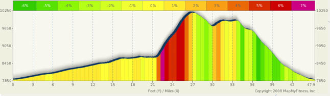
I decided to talk about this route as a one-way point to point between Antonito, CO and Chama, NM mainly because the two passes are so close together and if you do one, you might as well do the other. The nature of this route is similar to what you’ll find over Slumgullion and Spring Creek (only no where as hard). In fact, the profile looks a lot like Slumgullion and Spring Creek without the 9% grinds and high altitude. And, except for a train yard on the top of Cumbres, the terrain reminds me a lot of Gore and Rabbit Ears… rolling hills at the top, neat scenery, a two peak summit, and, if there at the right time of the year lots of wildflowers. Note, however, that the environment around these passes is very different than than what you’d find in northern Colorado. You are in the south here and the approaches to the pass, especially from Antonito, is likely to be hot and dry in the summer. The roads are more in the open and you know you are not in Kansas anymore. This is the west and the Spanish heritage of the area is very very apparent and welcoming. Overall, this is a ride of incredible beauty over rolling, not jagged hills. The climbing is not too steep and the downhills are fast.
The first 13 miles out of Antonito is nothing special from a scenery standpoint. The Conejos River meanders off the side of the road and provides enough moisture to support a few trees and some green grass. Other than that, it’s an agricultural area. At about mile 7 you’ll encounter cliffs to the north and open expanses to the south. The area reminds me of the canyon like terrain between the Grand Mesa and I-70. At about mile 13, you enter the Rio Grand National Forest and you bike among aspen and pine groves and open flower filled meadows for the remainder of the ride. Lakes, trains, forests, rail road yards, stunning vistas and overlooks, are guaranteed to keep your interests.
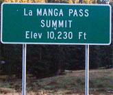
The transition from low rolling hills/flatlands to mountain goat territory is sudden and dramatic. In less than a mile, you go from virtually flat to 7% to 9% grades. The steepest portion is at about mile 22 and is fairly short. From mile 23 onward you will settle into a 5%-6% grade with only an occasional bump over 6%. You’ll find the summit at mile 27. On thing you will notice up here is the lack of the typical jagged peaks you see elsewhere. The hills are more rounded and you are looking at ridgelines more than sky high mountains. The hills are covered in green.
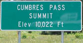
A short and quick three mile descent brings you to the “climb” to Cumbres Pass. I say “climb” because this really is more like the rolling hills between the west and east summit of Rabbit, and, again, this really does remind me of Rabbit Ears pass… both in beauty and nature. After navigating the railroad tracks at the summit, the remainder of the ride is down through the forests in a steady plunge of 5% to 6%, with an occasional 7%.
If you want to get away from it all. This is the pass to do it on. It’s been deserted the few times I’ve been down that way.