 West Summit out of Steamboat Springs
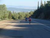 Mid Mountain climb out of Steamboat Springs
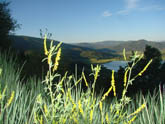 View of Yampa Valley out of Steamboat Springs
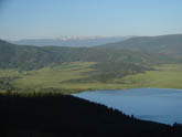 View of valley early in climb
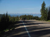
 Road between east and west summits of Rabbit Ears Pass
 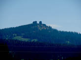 The Rabbit Ears
 On road out of Steamboat Springs, before climb begins
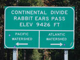 The pass
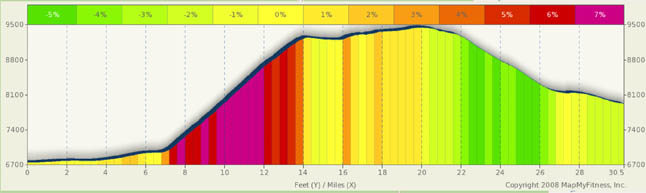
Pass Summary: Rabbit Ears/ Muddy Pass
I didn’t always like this pass, but I’ve grown to really like it. The main reason is, after a climb, I like the instant gratification of a long downhill. You don’t get that here. The east and west summits are separated by 7 miles, making it similar to Gore Pass (in fact, it’s the same Gore Range you’re crossing). Those middle 7 miles are beautiful and serene, making the climb well worth it.
You’ll find the climb up the west side to be breathtaking and easy to reach from Steamboat Springs (starting point for this ride is the rodeo grounds). Iif you are climbing the east side, it must be because you are either doing a long point to point tour and this side of the pass stands between you and Steamboat Springs, or you got lost and had to turn around. There really is nothing east of the pass for long long time. The CO 184 starting point is just a landmark to start/stop at. There’s not much to choose from unless you go all the way to Kremmling. And even there, there’s not a lot.
Starting at the Rodeo grounds a couple of block off the main drag, you’ll find a park and large parking area. The east bound ride out of Steamboat (actually south) on Hwy 40 has you escaping the hustle and bustle of a first class tourist mecca trekking through the flat Yampa River valley for a little over seven miles. Then, for the next seven and a half miles you follow a fairly constant, and surprisingly straight ramp straight up the face of the Gore range. The average road grade is a relentless 6.5% to 7.5% with no real relief during the ride. The top two miles do back off a bit, but you’re tired and won’t really notice it. For most of the ride, a glance over your right shoulder gets you a great view of the Yampa River Valley as it falls away below you.
The pass also gives you a rather unique two for one deal. As you complete your seven mile climb, you summit at Rabbit Ears West Summit. It’s not the pass… that’s still over seven miles ahead of you. However, you are done with your major climbing and a look over your back will give you a view that makes the climb worth it. If you climb this pass early in the morning, the early light illuminates the valley below you with vivid colors. Note, however, that morning climbs, even in summer, can be quite cold and you are shaded from the sun for much of the trip. From the west summit, you have a brief downhill, less than a mile, followed by a couple of rollers. The next seven to miles has you undulating through lush green meadows 9,400 feet up in the air. The roads are wide and smooth. You can really hammer these hills if you want, but you will miss some great scenery. Up here the air is fresh and cool and, of all the times I’ve been up there, it’s always the green foliage against the deep blue Colorado skies that I remember.
When you finally get to Rabbit Ears Pass, you have a choice. You can turn around and backtrack for eight miles to the west summit and then scream down the pass. This is one road where you can hit some serious speed. Or, you can head down the east flank. Muddy Pass is a mere 3 miles below Rabbit Ears. The roads are wide, but there is one hairpin to watch your speed on. I once saw a biker launch himself into the forest because he took the turn to fast.
The average grade on this side is 4.5% with a maximum just over 6%. If you choose to go past Muddy Pass (not really marked, but is at the CO 14 intersection), have fun. It’s 27 miles to Kremmling and the road trends downward with a few nasty rollers as you get to Kremmling. There really isn’t much of a descent past Muddy Pass. If you like riding in high cattle country, then the extension to Kremmling is for you. You will, however, be largely on your own so bring food and extra water. There’s nothing out there. Kremmling has nice people and a few basic services, but not much else. You can say hi to the cattle along the road. Instead of Muddy Pass, you may do better to just turn around at the east summit and go back to Steamboat for a beer or a swim in the hot springs. You’ll have earned a good rest.
Alternate Routes
In the above description, I advocated just doing a day trip, Steamboat to Rabbit Ears, and back because there is nothing east of the pass. However, an interesting near century ride would be a loop from Steamboat, over Rabbit Ears, down to Hwy 134, over Gore Pass to Hwy 131, and back to Steamboat (via Stagecoach Resv. Via County road 14). This gets the best climb and scenery of Rabbit Ears, the best approach to Gore, and a nice ride among the flat tops west of the Gore range. The towns of Toponas, Yampa, and Oak Creek have basic services, food and drink and the scenery is quite nice. The ride on the western slope trends upwards with a few rollers. Depending on the approach to Steamboat, you can even add a few significant climbs to drain the remaining energy in your legs.
Also, for a point to point trip, you can Climb Rabbit Ears and take a left at Muddy Pass on CO 14 and head to Walden. It’s a 60 mile total jaunt with about 3300 ft of climbing. Once down Muddy Pass, it’s a fairly flat road with two speed bumps built in to keep you interested. You are riding in high cattle country, but the snow capped peaks along the continental divide follow you the entire way (to your left, west). Striking scenery!