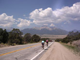
 Approach to Buena Vista from Trout Creek Pass
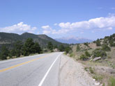 Views from westbound 24 near Trout Creek Pass
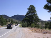 View near Wilkerson Pass
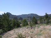 Typical Route 24 scenery
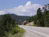 Near top of Trout Creek Pass
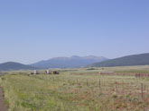 South Park Valley
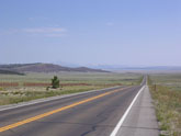 South Park Valley looking north from Altero Junction area
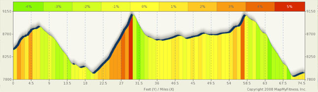
Route Summary: Woodland Park to Buena Vista via Trout, Wilkerson, Ute Passes
I was trying to think of the best way to present these CO Hwy 24 passes and ended up with just putting all three together for one nice long 75 mile day. As stand alone passes, these are nothing special, and Trout Creek really isn't even a pass. However, combined, it makes for a great ride with only moderate difficulty (based on mileage, not altitude or elevation gain).
Ute Pass is really funny as you are riding out of Woodland Park surrounded by residential and commercial buildings along a more or less lightly forested high plain and, when you expect it least, you’ve reached the summit only to find a stop light there. The grades are so minor at the top you think you are out for a Sunday stroll with your grandmother. In all seriousness, this is a very easy ride from Woodland Park and the only real scenery is Pikes Peak to the east.
Between Ute and Wilkerson, Wilkerson being the high point for the ride, you have a gentle descent down to the Florissant Fossil Beds. This is a really neat area to go into. Petrified trees and fossil beds are abundant and it would make a nice rest stop after the 20 mile rise and fall over Ute. A bit west of Florissant, after you bottom out, you will come across the hardest climbing of the ride. The climb will be among woodlands and forests as the road winds about eight miles to the summit. Most of the climb will be in the 4% range, which is shallow by Colorado standards, with the final mile in the 5% range. The west face of this hill is much shorter, about four miles, and has grades only in the 3% to 4% range. At this point, you are getting into the grasslands and ranches of South Park and are again more or less in the open. Special note here, the view of the South Park valley from Wilkerson Pass is spectacular. This view alone is worth the trip. You feel like you can see forever.
The next 25 miles has you in the South Park Valley on small to medium rollers between flat expanses until you get to Trout Creek Pass. The actual climb is done in two short stages: a mile and a half of 4%, followed by a flat area (Antero Junction), and then a couple of miles at 4% to 5% to the top. The west side of this pass is nothing but fun as you descend to Buena Vista. The landscape has changed to desert canyons and is quite impressive. The grades seldom exceed 4% in this area, which makes it easy to climb and easy to get some good speed going.
Alternate Routes
Despite being a bit on the remote side, using this route as part of a tour actually puts you in a very good spot to access some of Colorado’s most scenic and most alluring passes/rides.
You can add about 18-20 miles to this ride and a couple thousand feet of climbing if you start the ride in Colorado Springs. A number of years ago, I started the day with a ride through the Garden of the Gods and then through the Pike National Forest and Manitou Springs to Woodland Park. This climb up to Woodland park was a bit of a leg burner and the scenery was quite nice. The only drawback is that this can be a high traffic area. However the roads are good and shoulders are wide.
From Buena Vista, access to Cottonwood Pass, Monarch Pass, Independence Pass, Tennessee Pass, and Fremont Pass is very simple. From Antero Junction, access to Hoosier Pass, Red Hill Pass, and Kenosha Pass is very easy. The only caution here is summer heat in the South Park Valley.
From Woodland Park, access to Evergreen and Mt Evans, Berthoud Pass, and the Peak to Peak Highway, eventually connecting with Estes Park and Rocky Mountain National Park is easy.