 Approach to Willow Creek from Rand area
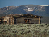 Scenery along the way
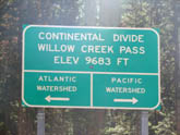 Willow Creek Pass
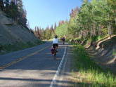 Climbing Willow Creek from rand
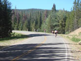 Climbing Willow Creek from Rand
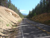 Road cut-outs make for less significant grades
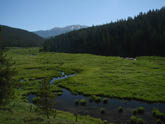 Granby side of Willow Creek is much more green than Rand side
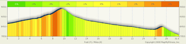
Pass Summary Willow Creek Pass
NOTE: This route was impacted by the October 2020 East Trouble Fire between Granby and Rand.
I like this pass. It’s one of those passes that really get you away from it all, and it’s really not that far away. The Front Range North is dominated by Rocky Mountain National Park and about the only other big pass in the neighborhood is Cameroon Pass. However, tucked away between the thriving metropolis of Walden, CO and the western gateway of RMNP, sits a little visited but very scenic and very easy pass on CO 125: Willow Creek Pass. It’s a Continental Divide pass, but it’s only 9683 feet high. It’s northern side sits on fairly high arid ranchland where it’s not uncommon to see antelope and elk. The southern face sits square in the Routt National Forest and is heavily forested (though the pine beetle is unfortunately present in the area). And beyond that, it’s an easy ride from both directions.
From Rand, don’t blink or you’ll miss it, it’s a nine and a half mile climb to the summit. The first six miles are through rolling ranchland, trending upwards at a 1% to 3% grade. Nothing too strenuous. As you move on and gain a little altitude, the density of the trees picks up and the views of the surrounding hills are blocked out. By mile 6, with only three and a half miles to go, you find yourself among the trees and a few road cut-outs climbing at a 3%-5% clip. It’s actually a bit steeper around mile 8 and backs off a bit shy of the summit.
From CO 40 (basically Granby), you are looking at a 21 mile climb (and one mile descent) to the summit. But not to worry, the total trip average grade is only about 1.5%, meaning that, for the most part, this is a rather simple climb. Stuck deep in the heart of the Routt Forest, the entire climb is tree lined and scenic. While there are no sweeping vistas, snow covered peaks to the east and rolling hills to the west keep the ride fun. The first three miles of the ride are about the most difficult as you do have to contend with grades approaching 5.5%. However, your efforts are rewarded with a nice downhill for a bit over a mile and then little more than a 1% climb for the next 12 miles. The real climb in this side does not start until mile 18 when the grades ramp up to 4% and 5%. But it’s only a four mile climb and the scenery keeps you interested.
This is a great low traffic scenic ride for beginners and a great ride for the more advanced, particularly if you do a point to point ride from Gould to Granby.
Alternate Routes
As noted above, this is a great low traffic scenic ride for beginners and a great ride for the more advanced, particularly if you do a point to point ride from Gould to Granby. Starting in Walden or heading to Walden will add 22 miles to the ride with insignificant altitude gains. From Walden, you can head toward Gould and Cameroon Pass, a 10k plus pass, that you can ultimately take back to Fort Collins and enjoy a 50 mile downhill sprint. Also from Gould, you can head west and enjoy Rabbit Ears and Gore Passes.
From Granby, you have two spectacular options, east to Rocky Mountain National Park or south to Winter Park and Berthoud pass. You can also head west out over ranchland on your way to Kremmling and Gore/ Rabbit Ears passes.
Riding Willow Creek really does help keep options open for many other Colorado rides.