Inverness CA to San Francisco CA
Fact Table:
| Location | Northern CA coast |
|---|---|
| High point | 663 ft |
| Max Grade | 9% |
| Route Distance | 40 mi |
| Elev Gain | 2100 ft |
| Rating | Moderate |
| Access City | Inverness or San Francisco |
Ride Tips:
Use caution while on Hwy 101
Traffic will be heavy in SF area
Carry food and water with you
Carry camera
Virtually the entire day is in a state park or on a national sea shore. What a way to come into San Francisco! Tomales Bay Ecological Reserve, Point Reyes National Seashore, Bolinas Lagoon, Stinson Beach, Muir Beach, Mt Tamalpais State Park, Sausalito, and finally, the Golden Gate Bridge. Welcome to San Francisco and make sure you have your camera on this 40 mile day.
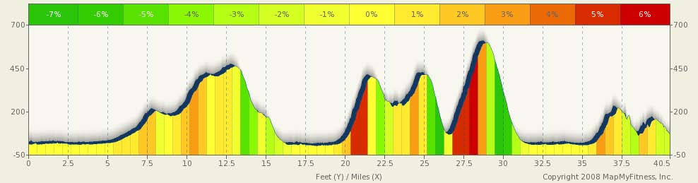
Yes, you have some climbing today, particularly as you work your way from the coast to Sausalito and the grades could get steep (up to 9% for short distances). But it’s all worth it.
Enjoy the day. Also, when you look at the Interactive map, don't pay attention to the 658,000 vertical foot gain or what looks like you need a submarine for. It's off by 656,000 feet. Judge from the profile above.
0 mi |
Start |
|
4.49 mi |
Turn right at CA-1 S/Sir Francis Drake Blvd Continue to follow CA-1 S |
|
26.41 mi |
Turn right at CA-1 S/Shoreline Hwy |
|
28.69 mi |
Turn left to stay on CA-1 S/Shoreline Hwy |
|
29.97 mi |
Turn left at CA-1 S |
|
30.45 mi |
Turn right to stay on CA-1 S |
|
32.22 mi |
Take the 2nd right to stay on CA-1 S |
|
32.39 mi |
Take the ramp onto US-101 S |
|
32.83 mi |
Take the exit toward Marin City/Sausalito |
|
33.09 mi |
Turn left at Donahue St |
|
33.27 mi |
Take the 1st right onto Bridgeway |
|
35.15 mi |
Turn left at Anchor St/Humboldt Ave |
|
35.19 mi |
Turn left to stay on Anchor St/Humboldt Ave |
35.2 mi |
Take the 1st right onto Spinnaker Dr |
|
35.35 mi |
Turn left at Bridgeway |
|
35.89 mi |
Take the 3rd right onto Richardson St |
|
35.93 mi |
Take the 1st left onto 2nd St |
|
36.14 mi |
Turn left at South St |
|
36.23 mi |
South St turns slightly right and becomes Alexander Ave |
|
37.46 mi |
Merge onto US-101 S via the ramp to San Francisco Toll road |
|
39.46 mi |
Take the exit toward 25th Ave Toll road |
|
39.5 mi |
Merge onto Merchant Rd |
|
39.67 mi |
Turn left at Lincoln Blvd |
|
40.1 mi |
Turn left at Long Ave |
|
40.3 mi |
Sharp right at Hamilton St |
|
40.51 mi |
Slight left at Pearce St |