Point Arena CA to Jenner CA
Fact Table:
| Location | Northern CA coast |
|---|---|
| High point | 653 ft |
| Max Grade | 6% |
| Route Distance | 52 miles |
| Elev Gain | 1900 ft |
| Rating | Moderate |
| Access City | Point Arena or Jenner CA |
Ride Tips:
Bring Camera
Remote, bring food and water
Watch for traffic in cliff areas
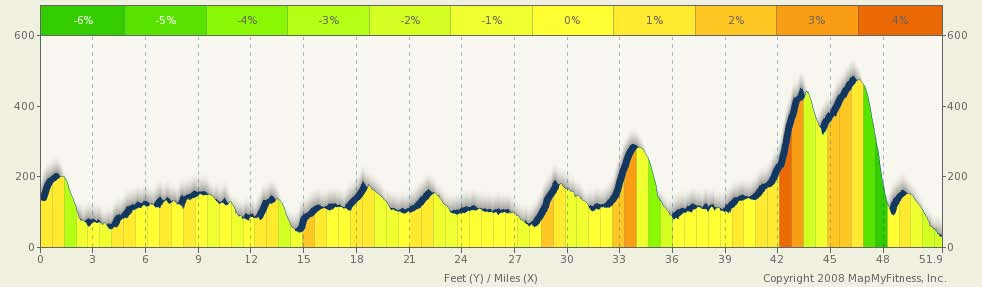
This is a very scenic day. More trees than yesterday, more panoramic vistas, and fewer rollers. While you are on or near the coast most of the day, you won't always see the ocean, but the late night and early morning for and low clouds will likely be present (except in the fall, when it is often clear). The majority of the climbing today will be toward the end of the day. There are not too many towns to pass through, but you will pass by some state beaches (Schooner Gulch), through a golf course, around Gualala Point county park, Fruse Rhododendron state reserve, Salt Point state park, Stillwater Cove, and toward the end of the day, a very scenic ride through Fort Ross State Historic Park. Jenner is small, bet beautiful. The climbs at the end of the day are breath taking in more than one way.
0 mi |
Start south on Hwy 1 |
|
10.48 mi |
Turn right to stay on CA-1 S/Coast Hwy/Shoreline Hwy Continue to follow CA-1 S/Coast Hwy |
|
18.7 mi |
Turn left at Deerfield Rd |
|
18.74 mi |
Take the 1st right onto Lupine Close |
|
19.08 mi |
Turn left at Deerfield Rd |
|
51.8 mi |
Take the 1st left onto La Porte Dr |
|
51.84 mi |
Turn left at Hereford Dr |