Plum City Loop
Last update: 11/2020
Fact Table:
| Location | West Central WI |
|---|---|
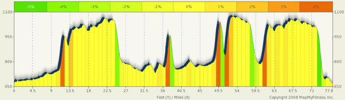
| High point | 1194 ft |
| Max Grade | 16% |
| Route Distance | 78 mi |
| Elev Gain | 2411 ft |
| Rating | Difficult due to distance and hills |
| Access City | Maiden Rock, WI |
Ride Tips:
Follow cue sheets carefully. Complicated route
Towns few and far between, carry extra food and water (and tire repair kit)
Watch speed on downhills as there may be sand washed up on roads
Download GPS route from mapmyride.com to help
This is a favorite WI ride of mine and I found it put together/designed by the Twin Cities Bike Club. The route is a bit complicated so use caution in making turns or you can get lost and end up in Iowa or Illinois. It is scenic, hilly, and remote. A perfect ride to get away from it all. Towns are few and far between, but you do cross Plum City twice , so you are able to refresh your water and food supplies.
The starting point for this ride is Maiden Rock, WI at the city park on the shores of Lake Pepin. There are a few bars in town (this is WI after all) for food and drink after you complete your ride. The route gives you a nice warm-up about 12 miles before it throws any hills at you and then, when it does, the hills in the area are typically short and steep. Each of the major climbs (showing a mere 4% on the profile) have segments, in reality, closer to 10%-14%. There is even one short segment where you are standing at the top of a “dip” in the road and you think you can power down the dip and coast back up the other side. Well, I don’t know the grade of the dip (it is very short), but I have never bled off speed so fast… you literally hit a wall. This is a very fun route.
0 mi |
Start |
|
0.05 mi |
Turn left at Great River Rd/Main St/WI-35 N Continue to follow Great River Rd/WI-35 N |
|
0.66 mi |
Take the 1st right onto 385th St/E River Rd Continue to follow 385th St |
|
5.34 mi |
Turn right at Co Rd A |
|
8.74 mi |
Turn left at US-10 W |
|
9.66 mi |
Take the 1st right onto 400th St |
|
10.88 mi |
Turn right at 450th Ave |
|
12.77 mi |
Take the 1st left onto 350th St. NOTE: this turn is easily missed. The left is part way down the hill. If you do miss it, you can continue on 450th until the route turns back onto 450th at mile 19.01) |
|
13.27 mi |
Turn right to stay on 350th St |
|
15.01 mi |
Turn left at 330th St |
|
15.79 mi |
Turn right at WI-72 E/WI-72 Trunk E |
|
17.01 mi |
Turn right at 270th St |
|
19.01 mi |
Turn left at 450th Ave |
|
19.51 mi |
Take the 1st right onto Co CC S |
|
21.55 mi |
Turn left at 370th Ave |
|
23.05 mi |
Continue onto 190th St/Elm Tree Dr |
|
24.03 mi |
Turn left at US-10 E NOTE: After your turn onto 10 you will be making an almost immediate left onto 330th. Use caution crossing 10 to the left because oncoming cars are screened from you by the crest of the hill to the right. |
|
24.27 mi |
Take the 1st left onto 330th Ave |
|
26.08 mi |
Turn right at Co Rd S |
|
27.74 mi |
Turn right at Co Rd S/Pine Ave E |
|
27.81 mi |
Turn left at Co Rd S/Main St Continue to follow Main St |
|
28.5 mi |
Continue onto Co Rd U |
|
31.7 mi |
Turn left at Co Rd Uu |
|
33.57 mi |
Turn left at Co Rd SS |
|
34.12 mi |
Continue onto Co Hwy Ss |
|
39.2 mi |
Turn left at Plummer Rd |
|
40.69 mi |
Continue onto Co Rd Y |
|
41.69 mi |
Continue onto Lamphere Rd |
|
42.68 mi |
Take the 1st right to stay on Lamphere Rd |
|
43.37 mi |
Turn right at US-10 E |
43.62 mi |
NOTE: a left onto HWY 10 can be a short cut back to Plum City. This eliminates about 9 miles. Take the 1st left onto Co Hwy G |
|
44.53 mi |
Turn right at Co Hwy Z |
|
45.52 mi |
Take the 1st left onto Co Hwy X/Co Hwy Z |
|
47.42 mi |
Slight left at Co Rd XX |
|
49.34 mi |
Continue onto 10th Ave |
|
49.48 mi |
Continue onto Weber Rd |
|
50.24 mi |
Turn left at Hartung Rd |
|
51.78 mi |
Turn right at Patnode Ln/Z Continue to follow Z |
|
54.03 mi |
Z turns right and becomes Co Rd Z |
|
54.98 mi |
Turn left at Co Rd ZZ |
|
57.47 mi |
Turn right at US-10 W |
|
59.57 mi |
Turn left at Pine Ave E |
|
60.08 mi |
Turn left at Co Rd S/Main St Continue to follow Main St |
|
60.31 mi |
Take the 2nd right onto Co Rd S/Main St/Maple Ave W Continue to follow Co Rd S |
|
62.08 mi |
Turn left at 190th St/Blue Jay Dr. NOTE: this turn can be easily missed if not paying attention. |
|
64.59 mi |
190th St/Blue Jay Dr turns slightly left and becomes 130th Ave |
|
65.06 mi |
Take the 1st right onto 170th St/Plum Creek Rd |
|
65.57 mi |
Turn left at Co CC S |
|
68.28 mi |
Turn right at Pine Ln |
|
68.4 mi |
Slight left at Co Hwy J |
|
71.81 mi |
Continue onto Co Hwy K |
|
72.88 mi |
Turn right at Co Rd E |
|
75.2 mi |
Continue onto Co Rd Aa |
|
75.54 mi |
Turn left to stay on Co Rd Aa |
|
76.32 mi |
Slight right at Great River Rd/WI-35 N |
|
77.58 mi |
Take the 1st left onto Chestnut St |
|
77.62 mi |
Continue onto Park St |