 Ridgway State Park
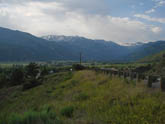 First climb out of Ridgway
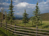
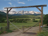 Ranch views on climb out of Ridgway
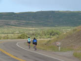 First sight of final four mile ramp up Dallas Divide from Ridgway
 Climb of Dallas Divide ramp from Ridgway
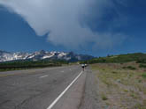 Near top of Dallas Divide from Ridgway
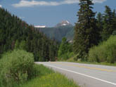 Climb from Placerville to Dallas Divide
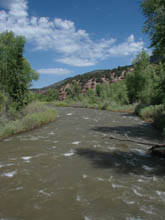 Base of climb in Placerville
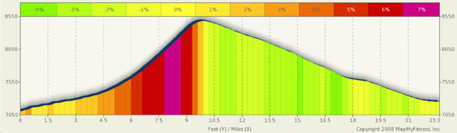
Dallas Divide Summary
LBack in 1997 this is the hill that hooked me on Colorado cycling. The Sneffels mountain range is a site you won’t soon forget: rugged, jagged, and forever snow capped and painted against a deep blue sky. You can talk about the major must do rides in Colorado, like Mt. Evans, Grand Mesa, and Rocky Mt. National Park, but you can’t forget the little climbs such as this. Like Vail Pass, this is a reasonable first time hill for those new to cycling and it is a splendid return visit for the experienced rider. The recommended starting place is Ridgway, both for ease of access and for services. You could start in Placerville, but other than a general store, there’s not much there.
From Ridgway, there’s only one direction and it’s up. You start the day with a little mile and a half climb up Knife Edge Ridge into the Dallas River wash. It’s a nice 3% to 4% climb as you leave Ridgway below you. For the next five miles you roll along on the floor of a beautiful green valley and shortly after you pass the Dallas Park Cemetery (about mile 3), you’ll get your first close up view of Mt. Sneffels: One of Colorado’s 14’ers, weighing in at 14,150 ft. You can stop here and take pictures all day, but let me assure you, you need to save space on your camera as the views only get better.
This portion of the ride has you climbing slightly at a 2% to 3% rate. The roads are great with wide shoulders and little traffic. The real climbing won’t start until mile 6 or so. Every turn you make opens up new vistas and you tend to be mesmerized by the Sneffels range on your left. (I also suggest starting in Ridgeway because if you choose this as your downhill run, you’d miss a lot of the scenery… this is also the first place I hit 60 MPH on a downhill in CO. At 60, there’s not much taking in the scenery).
As you meander along on Rt 62, you begin to sense the impending climb coming at you as, straight ahead, you see the ridgeline you will be climbing and if you squint, you’ll see the road, angling upwards, cut into the side of the hill. In one of the biggest switch backs you’ll find in CO., the road curves first to the right then sweeps to the left and you are now truly climbing. The real climb is only about four miles long, but it does get steeper near the top. On average, expect a 5% to 6% climb toward the bottom and upwards of 7.5%+ near the top. The climb is a basic ramp, unrelenting as it wraps around the base of West Baldy mtn. As you approach the top, the road briefly stops it’s right hand wrap around the mountain and takes a shallow left turn. The exit from this turn, for me, is the steepest part. The road then resumes it’s right hand turn tendency and you’ve made it to the top.
If you choose to start in Placerville, there is a general store in town for basic supplies. Stock up on liquids as the climb in front of you will be long and hot. It’s a 13 mile climb that is, more or less, a straight shot up hill at a 3% to 5% grade. This is not a steep climb and the roads are in great shape, but you are in a valley, wind will be light, and it’s likely to be hot (in summer, of course). If inclined, this is a great hill to try to power up in a nice medium low gear as, except for a small section where the climb flattens toward the bottom, the grade is rather consistent and even. There are no stunning vistas here as you are climbing out of a canyon and you really won’t get the stunning scenic views until you reach the top. None the less, it is quite a pretty ride and you won’t kill your knees doing it.
Alternate Rides
Other than extending this ride to Telluride, there's not much in the area that is "extra." However, riding the San Juans is special. There are a host of opportunities.
Durango is a good starting point for a number of different routes in the area. Each Spring, cyclist race the Durango-Silverton Railroad to Silverton. That, in effect, is the route detailed in my Coal Bank/ Molas summary.
On the grander side, the so-called “Death Ride” loop. A 230 mile 24,000 foot endurance test. Each July, the ride is sponsored as a one day jaunt in the San Juan’s. It’s a Durango to Durango loop… including Coal Bank Pass, Molas Divide, Red Mountain, Dallas Divide, Lizard Head, and then rollers back to Durango. If you have the strength, and desire to do this, good luck. Other mere mortals break this ride into two or three day segments.
Also out of Durango, heading west is a 47 mile ride that will take you to the town of Cortez, past Mancos and the Mesa Verde National Park. Lots of rollers and wide open ranch land. A ride through Mesa Verde is a must do.
And, of course, be sure to look at the Coal Bank and Molas Divide summary for more rides out of Silverton and Durango