 View below summit toward Keystone
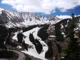 View above A-Basin ski area. Mid-way up Keystone side climb
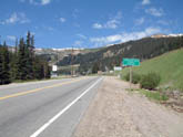 Base of climb near loveland ski area
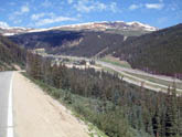 First ramp out of Loveland ski area
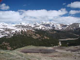 View of Continental Divide at top of pass
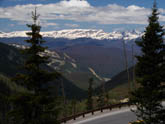
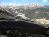 Looking down on I-70 and tunnel
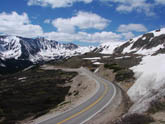 Near summit on Keystone side
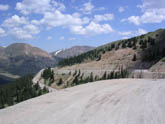 Final switchbacks to top, Loveland ski area side
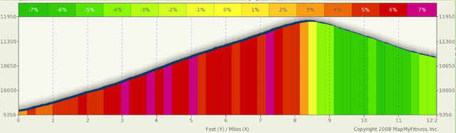
Loveland Pass Summary
I thought about the “moderate” rating for the Loveland Ski area side of the climb and had a bit of the same dilemma as the rating for the Silverton side of Red Mountain. Where Red Mountain is the hardest “easy” ride I’m showing, Loveland in the easiest “moderate” ride. It earns it’s moderate rating based on it’s near 12000 ft summit and on the sections of 9% climbs. It’s short… barely over four miles, but it is a constant steep. It also offers spectacular scenery as you look back and down on the Eisenhower tunnel and Interstate 70. The east side of the pass is perfect for people with limited time, for training rides, and/or for people newer to the sport of climbing Colorado passes on a bike and are looking for a bit of a challenge.
Climbing out of the Loveland valley, you are surrounded north, west, and south by 12k and 13k foot snowcapped mountains. Interstate 70, below you, disappears under the continental divide into the Eisenhower Tunnel. You are riding to one of Colorado’s highest passes and when you summit at the continental divide, you are truly at the top of the world. The downhill rides on both sides are a scream. Though short, the east side drops you 1,000 feet over four miles. The west side drops you 2,700 feet in about 9 miles. The roads are in good shape and are fairly wide despite there not always being a shoulder.
Starting your short climb from the east side at or near the Loveland Ski area parking lot is a good bet. While the ski area is closed in the summer, meaning no food, water or services, you could use the services of the area early and late in the ski season while it is open. The east side is fairly shaded and can be quite cold, so dress accordingly. This side is rather shielded from the sun by the mountains most of the day. During early and late season rides, watch for icy patches from snowmelt run-off.
You can best describe the east side climb as four one mile ramps with three hair pins. Only the last hairpin is tight, the first two are really just longer curves. Once past the last hairpin (mile 3ish) you are making your final assault on the summit. Also, it’s at this hairpin that you are at the top of the Loveland Pass ski area and you have a ski lift slightly below you to the left. It’s kind of fun to look down at a ski lift. After one more mile and a couple slight curves, you summit with a slight turn to the left. The world is below you and if it’s not too windy or cold, and if you have a bit of extra energy, you could walk a bit higher on the surrounding ridges for even better views.
The west side climb is longer, almost triples the elevation gain, and, at times, is steeper than the east side. Starting in Keystone, with the Dillon reservoir to your back, you start your real climbing at the State River campground. You are on Hwy 6 and the North Fork river is falling on it’s way to Lake Dillon on you right.
Surrounded by light forest and in the shadow of 11,800 foot Porcupine Peak, you follow a fairly straight shot to the NE. Six miles into the ride you come to the Snake River falls. Depending on water volumes, these could be quire fascinating to watch while you catch your breath at 10,700 feet.
Just slightly beyond the falls, you come across the Arapaho Basin Ski area. Because these folks are so high, they are generally the last ski area to close and first to open. You are roughly half way to the top here and you are about the leave the straighter segment of the ride behind you. As you loop around the ski area and navigate your first hairpin, you start to gain serious altitude and start really feeling the lack of air up here. Around mile 8 and 8.5 you come across two more hairpins and, once past those, you are on your final climb to the top of the world. Around mile 9.5 you are tricked into a little bit of a false summit just past Pass Lake. Your view of the summit is blocked by a small ridge and you may be a bit disappointed to find you still have a half mile of climbing when you reach the top of the ridge. At least the last half mile is not as steep as some passes treat you to.
Alternate Routes
If you want to tack on a few extra miles after a west side downhill run from Loveland into Dillon, you can add Swan Mountain Road to your itinerary (Start at the intersection of Co 6 and County 1, Swan Mtn Rd). The five mile route climbs about 500 ft and you are greeted with awesome views of the Dillon res. and a nice descent toward Frisco/Dillon. Watch out on the descent, however, as there are little to no shoulders and it’s quite likely that there will be a fair amount of traffic backed up toward the end of the road. This is a great route to get you set up for other rides in the Breckinridge, Dillon, and Frisco area. Copper Mtn and Vail pass are only a few miles onward.
On the Loveland Ski area side of the pass, you could add 24 miles to your ride and either a 3100 foot climb or descent by starting or stopping in Idaho Springs. If you start in Idaho Springs, you'll have a difficult 4200 foot climb over roughly 28 miles to the pass. You even get to spend a few miles on I-70 approaching/leaving the Loveland ski area. Enjoy.