 View from mile 21 Carbondale side
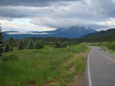 Leaving Carbondale
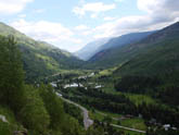
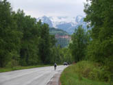 Entering Canyon Carbondale side
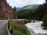 Scenic roads
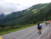 View of final climb up pass
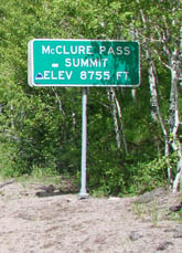 McClure Pass
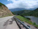 Paonia Resv.
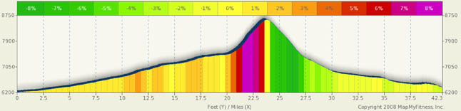
Pass Summary McClure Pass
Do not let the 8755 ft summit of this pass fool you. Yes, it’s low by Colorado standards, but it’s steep on both sides: 9% max grades on the Carbondale side and 8% max grades on the Paonia side. The climbs may be rather short, but they are intense. In addition, the pass is in an out of the way place and from either direction, you have a rather long uphill trek to get to the pass. From either direction, despite the two sides being very different in terms of scenery, the scenery is spectacular. Personally, I like the Carbondale side better, but, you won’t be disappointed by either side. Note: Because the Carbondale side is accessed via central Colorado, I've listed the location central. The Paonia side is accessed from the Western Slope and is more or less aligned with places like Hotchkiss and the Black Canyon. So I've choosen the western slope designation for the Paonia side.
Carbondale is roughly 23.5 miles from the summit and can easily be accessed From Glenwood Springs or Aspen. The drive out of Carbondale can be a little high traffic, but within a mile or so you are out in the open and are headed for a deep canyon. For 20 miles you meander along in a spectacular river canyon, complete with rapids, waterfalls, deep deep green forests, red rocks, cliffs, and even the cute little bed and breakfast town of Redstone (a must stop for a quick rest). The grade in this canyon is a consistent 1% to 2% with only a small section if 3%. It is a very pleasant very scenic ride. Take time to explore the surroundings.
Mile 20 marks the beginning of the real climb. As you proceed through the canyon, you see a massive rock wall in front of you, with the faint line of a cut out heading up. That’s the road. From the base, a long left turn marks the start of the climb and the switchback to the right places you square in the middle of a sustained 7% and 8% climb with sections near 9%. The views of the valley to your right just kep getting better and the only decision to make is which scenic overlook you want to stop at. Toward the end of your climb, a right then left hand curve deposits you at the top.
From the flip side, I suggest a start at the Paonia Reservoir. It’s a beautiful area and you start with a nice climb up the dam. The first 12 miles of this ride have you following the reservoir and its feeder river on either flat roads or 1% to 2% rollers. The roads are wide and the view of the mountains in the background is great. As you gain altitude away from the river and reservoir, you also start adding to your grades. By mile 15, you see the road in front of you wrap to the right at the back of the valley you are riding in. The ramp you are looking at may not initially look that bad, but the approach to it will be in the 5% to 6% range, and the ramp itself will top out in the 8% range and won’t back off until the very top. Like the Carbondale side, the climb is not that long, but it is steep. The views of the valley you are leaving behind are striking. However, it’s a wider and drier valley so it’s not as striking as the Carbondale side.
Alternate Routes
Alternate routes are rather limited. You can easily extend the ride on either end by starting from Glenwood Springs or Aspen on the Carbondale side, or head to the inland meca or Hotchkiss. From Hotchkiss, you have easy access to the Grand Mesa (a must do ride) or the Black Canyon and Montrose/Gunnison (another must do ride). From Aspen, Independence pass calls and from Glenwood Springs, the Glenwood Canyon is yet another must do ride.