 Near top of Red Mouontain from Silverton side
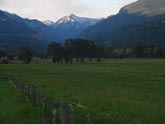 Approach to Red Mountain from Ridgway
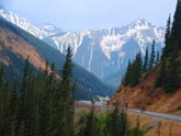
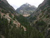 Climbing out of Ouray
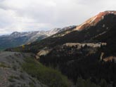 Road from Ouray up to Red Mountain Pass
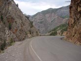 Ridgway side of Red Mountain climb
 Mid-Mountain flats on Ridgway side of pass
 Mind the gap on the right. Quick drop-offs
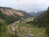 View at approx half way up ramp, near top of climb from Silverton
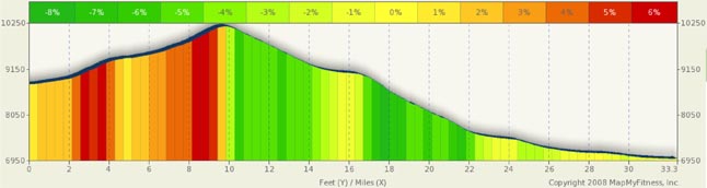
Red Mountain Pass Summary
I have never ridden Red Mountain Pass as a stand alone ride. I’ve ridden this pass many times combining Red Mountain with Coal Bank and Molas Divide. The ride between Durango and Ouray or Durango and Ridgeway is a gem and I detail it below on alternate rides.
I thought long and hard about the rating for the climb from Silverton to Red Mountain Pass. To be honest, I can easily be talked into making this a moderate ride based on altitude and vertical gain. But I fall back on only a 10 mile ride, less than 2000 feet gain, and some nice flatish segments. This is not a Vail Pass from Copper or Tennessee from Leadville, but if you have a limited amount of time and want a true alpine experience, and if you happen to be in Silverton, this is a reasonably easy out and back for you. Bottom line, this climb is the hardest of the easy ratings I’ve assigned.
So, the easy side first. From Silverton, you have a ten mile climb to Red Mountain Pass. The first four or so miles are rather benign when it comes to grades (about 2%-4%), but spectacular on the scenery side. You are in the heart of the San Juan’s surrounded by the rugged beauty of high mountain peaks. In these first few miles you will come across open good roads flowing over rollers with a couple of very short 5% grades thrown in. This really is the relaxing part of the ride and you won’t mind the grades. As you ride on, you start to see the area where the pass should be and your first thought is how the heck you are going to get from here to there, as there is a huge rock face between you and your objective. Gradually, the road carved into this face comes into view and you understand your fate. A one switchback two mile ramp will help you gain over 700 feet of elevation in a very short period.
The good news, the ramp is less than two miles long. The bad news, this is the steep part and you will hit grades of 7.5%. It’s not that bad as you will be focused on keeping your bike on the road. I’ve seen roads with drop-offs before, but this takes it to a new level. If you and heights are not mates, this will catch your attention. There are little to no shoulders to your right and, on my last trip through, the white line at the edge of the road was broken in quite a few places where it, along with the road, fell into the abyss. Said another way, if you tried to ride the white line or to the right of the line, you’d end up in a free fall hundreds of feet to the valley floor. Be careful. It’s an incredible ride. Once at the top of the ramp, you only have a few miles to go to make the summit. It will steep for short periods, but is a beautiful ride.
Coming out of Ridgeway, you have a daunting task in front of you: 23.5 miles and some 4100 feet of climbing. The roadblock in front of you both beckons and mocks you at the same time. You are riding south in a valley that gets narrower as you progress and there is no visible sign of escape: the rock face is solid and seemingly impenetrable. Your first five miles have little to no discernable climb, and the next five into Ouray are at a 3% to 5% grade. Good news… ten miles down and 800 feet climbed.
Now the fun starts. Immediately out of Ourey, you are greeted to three switchbacks. The views back to the town are great and are worth a look. As far as anyone is concerned, you feel like you are caught in a Swiss or German Alps village. From here through mile 17, the road will be uncharacteristically straight. A few curves here and there, water cascading down to your right. Drop offs getting deeper and deeper… and grades that are leg burning. Expect the norm to be 6% to 9% with little to no relief.
At about mile 17, you get a break. The road flattens for a good two miles… all the way down to flat to 2% as you ride through Ironton Park, a swampy area in the middle of a mountain. Once through this area, the climbing starts again, but at a slightly reduced grade. The remainder of the climb is in the 5% to 7.5% range. The steeper grades are on the many switchback and curves you’ll find here. In a short three mile segment shortly after Ironton Park, you will gain close to 800 feet in elevation and face 10 switchbacks and another 5 or six sharp curves. The roads are literally stacked on each other. You are surrounded by mining operations and red mountains. There is no other place I have ever been that is remotely like this. Despite the climb, it’s really a fun segment. From the top of the switchbacks, you only have a mile to go. Celebrate at the top. You deserve it.
Alternate Routes
Durango is a good starting point for a number of different routes in the area. Each Spring, cyclist race the Durango-Silverton Railroad to Silverton. That, in effect, is the route detailed in my Coal Bank/ Molas summary.
On the grander side, the so-called “Death Ride” loop. A 230 mile 24,000 foot endurance test. Each July, the ride is sponsored as a one day jaunt in the San Juan’s. It’s a Durango to Durango loop… including Coal Bank Pass, Molas Divide, Red Mountain, Dallas Divide, Lizard Head, and then rollers back to Durango. If you have the strength, and desire to do this, good luck. Other mere mortals break this ride into two or three day segments.
Also out of Durango, heading west is a 47 mile ride that will take you to the town of Cortez, past Mancos and the Mesa Verde National Park. Lots of rollers and wide open ranch land. A ride through Mesa Verde is a must do.
And, of course, be sure to look at the Coal Bank and Molas Divide summary for more rides out of Silverton and Durango