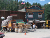
 Minturn, CO
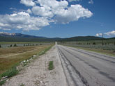 Highway from Leadville to Tenessee Pass
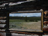 Abandoned cabin Leadville side of pass
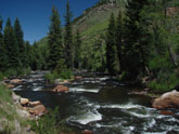 One of many rivers and lakes along the way
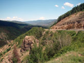 First climb out of Minturn, near Red Cliff
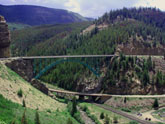 Neat bridge at Red Cliff
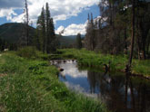 Lakes and streams at 9000 feet
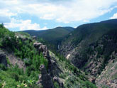 Canyons out of Minturn
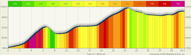
Tennessee Pass Summary
No, this is not a new roller coaster at Valley Fair Amusement Park, it’s a neat little pass in central Colorado, connecting Leadville to Eagle County over the Gore range. There’s a lot of history on this route if you are into World War 2, as this was the training grounds for the 10th Mountain Battalion. You pass by the remains of Camp Hale and find a tribute to the army division on top of Tennessee Pass. And, of course, you start/end in either Leadville, the highest city in the US, or start/end in Minturn, gateway to the western slope or the skiing offered by Summit County. This is also part of the famed Copper Triangle ride. See a description under alternate routes.
The easy way first… Leadville to TN pass. If you find yourself in the city of Leadville and want a touch more of a challenge than riding the new trail around the town, here’s a great alternative. Just ten miles from central Leadville is Tennessee Pass, and it’s only about 500 feet of climbing. Actually, the return to Leadville might actually be a bit more difficult than the pass itself as there is a short 5% climb back into Leadville. From Central Leadville, it’s a six mile downhill/flat ride to the base of the climb, and then only a four mile 4% climb to the top. You might be having such a good time on the climb, chatting with your friends, and looking at the scenery, you might not even realize you are climbing! (OK, that’s a slight stretch, but it really is a scenic easy climb).
The real fun is the ride up from Minturn. Spectacular scenery is to be had all the way. Roaring rivers and canyons to start, followed by a first forested then open climb on a road carved into the hills, deep canyons to your right. An incredible bridge at Red Cliff, a two mile plunge, more forests, a long flat plateau with copious amounts of trout streams and lakes. When you start your final assault in Tennessee Pass, it’s a moderate four mile climb complete with switchbacks. This ride has ever changing scenery and will not be boring.
The first 2 ½ miles out of Minturn are scenic and fairly flat. You are going up, but it’s not too bad. However, all of a sudden, you are hit with the hardest climbing of the ride: a three mile climb with 6% to 7.5% constant grades. If this doesn’t get the blood pumping, nothing will. This is steep, scenic, constant, and gets you over 9000 feet quickly. From the top, you can see a great bridge spanning the canyon into Red Cliff. Between miles 10 and 12 you have a moderate climb back over 9000 feet and enter a long plateau area, mostly flat with a few rollers. It’s at this point you pass Camp Hale and numerous trout streams. It’s a great respite to the climbing and, as always, incredibly scenic.
Around mile 15, you start your final climb. The summit is around mile 21 with the steepest areas early in the climb, and again toward the top at the switchbacks. The middle few miles are in the 4% range. At the top, be sure to take a look at the army memorial. The downhill to Leadville is short followed by six miles of flat or 3%-4% climbing into Leadville.
Alternate Routes
This pass is part of the Copper Triangle and Shrine Pass. You may want to try either for a change of pace. First, the Copper Triangle… three passes, 78 miles and just under 6000 feet of climbing. Starting at Copper Mtn., head south CO 91 up Fremont pass (11,318 ft). And then down to Leadville. From Leadville, it’s CO 24 over Tennessee Pass (10,424) down to I-70. The climb up TN pass from the south is fairly easy as you are already near 10k in Leadville (comparable to the ease of Vail Pass from Copper Mtn), but, you must also cross Battle Mtn before you reach 70. There is also a significant speed bump outside of Minturn that you must contend with, but is not to be overly concerning. From 70, a combination of road and trails will take you back to Copper over Vail pass. I’ve done this route a few times and loved it… It was a long day for me but worth it.
Shrine Pass Road is a dirt road accessed from the Vail Pass rest area. It’s a great back country ride for mtn bikes or cross/cyclo-cross bikes. I once started in Vail, climbed the pass and then veered to Red Cliff via Shrine Pass road and returned to Vail using the roads and trails along 70. The RT loop to Vail is about 40 miles with 5000 ft of climbing. I wouldn’t take a road bike on unless you have appropriately wide road tires (700x32+), but the back country scenery makes it well worth the ride. Shrine Pass road is not heavily traveled or maintained and while the dirt road up the western flank of Cottonwood Pass is better than some paved roads, Shrine pass road is likely to be washboard, rock, and gravel.